

trending: 1000 steps / kokoda memorial trail – dandenong ra... why i hike alone: 5 awesome things about walking solo i... that time i dragged my lady up a mountain and asked her... about best walks of the great ocean road about me about bushwalking blog authors sponsorship & ads guest posting blog disclaimer plb hire links find a trail the trail finder map travel inspiration food, gear & tech other tips & how tos conservation news & opinion photography bits & pieces contact select page kalymna falls – grampians (gariwerd) national park – victoria posted by neil fahey | 21 jan, 2009 | 0 | date of walk: 15/01/2009 length (km): 1.5 km time (hrs/min): 1 hour
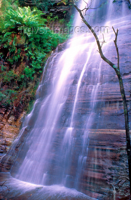
grade: easy return / circuit / one-way / partial circuit: return region: western victoria park: grampians (gariwerd) national park closest town: moyston ascent: 100 m maximum height: unknown map: none available (i wasn’t able to find one via parks victoria or dse and copyright prevents me from providing any others – however, a map is not necessary as it will be easy to follow the track with my notes and the southern walks map i’ve mentioned below) further details / source(s): grampians (gariwerd) national parks – southern walks (brochure available from halls gap visitor information centre – $3.30). no specific information on this walk is available from parks victoria or dse. getting there: moyston is on the road between ararat and halls gap (not the western hwy – pretty sure the number is c222). if heading towards halls gap, turn left at the moyston general store (there will be a sign to dunkeld and mafeking). follow this road for quite a while until it becomes unsealed. the map on the grampians (gariwerd) national parks – southern walks brochure represents the road as sealed here but it is incorrect. soon after the unsealed road begins, take the road to the right called mt. william picnic ground road (signed). the mt william picnic ground road is quite good but at the point where it becomes less 2wd friendly, there will be a sign for the kalymna falls picnic area. the brochure states that the remainder of the road is blocked by a permanently closed gate but when we arrived it was not closed so make sure you look out for the sign. comments: from the picnic ground, walk back to the road and continue west on the gently climbing track. after about 690 metres there is a signed turn-off on the right to kalymna falls (the sign says 600m but don’t worry, it’s really only 60m). i’d like to see the falls after rain but they were really nice as they were. the water was taking a few different paths down the rock-face and coupled with the lush ferny gully, this created a beautiful scene. kalymna falls share: rate: previous lar-ne-jeering walk – langi-ghiran state park – victoria next gulgurn manja shelter – grampians (gariwerd) national park – victoria about the author neil fahey bearded man. hiker. traveller. blogger. melbournian. mayora. writer & online comm's guy. step-dad. husband. founder of the bushwalking blog, aussiehikingtours.com, and aussie outdoor deals. related posts grey gum walking track – dandenong ranges national park – silvan – victoria december 31, 2009 melbourne park walk: sweeneys flats to griffith park – eltham – victoria january 5, 2009 maits rest rainforest walk – great otway national park – apollo bay – victoria april 20, 2009 gold heritage walk – warrandyte state park – warrandyte – victoria june 2, 2009 leave a reply cancel reply your email address will not be published. required fields are marked * comment notify me of followup comments via e-mail name * email * website subscribe to bushwalking blog's e-mail newsletter wordpress theme by elegant themes | customised by neil fahey | hosted by netorigin
Please Share This Page: